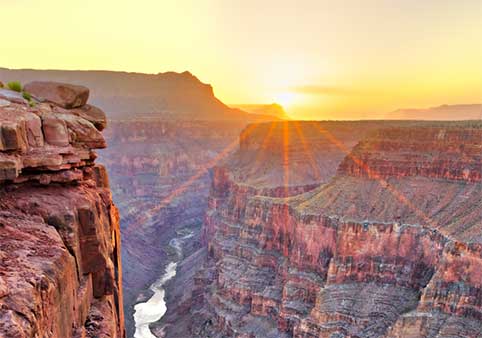
A first view of the Grand Canyon can feel almost impossible to organize. Cliffs overlap with distant ridges, side canyons disappear into shadow, rock layers repeat across the landscape, and the Colorado River may be hidden even though it flows through the canyon below.
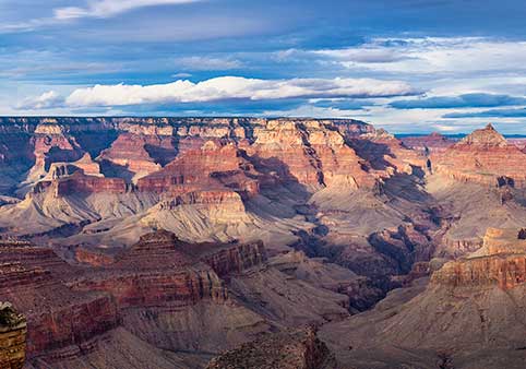
The view becomes easier to understand when it is read in parts. The level rim records the surface of the surrounding plateau. Cliffs and slopes reveal different rock formations. Buttes and temples are remnants of layers that once extended farther across the landscape. Side canyons connect the rim with the river corridor, while the dark inner gorge exposes some of the canyon's oldest rocks.
This guide explains the major features visible from Grand Canyon overlooks. It is not a guide to finding the best parking space or fitting the most stops into one day. It is an introduction to seeing the canyon as a connected geological, ecological, and cultural landscape.
Begin with the Shape of the Landscape
The Rims and Plateau Surface
The South Rim and North Rim are edges of the Colorado Plateau. From many overlooks, the land beyond the canyon appears comparatively level even though it contains forests, drainage systems, hills, faults, and smaller changes in elevation.
The broad surface near the rim is supported largely by the Kaibab Formation, the youngest major rock layer commonly visible at the top of the canyon. These rocks were deposited long before the modern canyon existed.
The North Rim is generally higher than the South Rim. Its greater elevation contributes to cooler conditions, heavier snowfall, and denser forests. Looking across the canyon therefore means looking not only across a great horizontal distance, but also toward a different elevation and ecological setting.
Cliffs and Slopes
The canyon walls do not descend as one smooth surface. They form a repeating sequence of cliffs, ledges, benches, and slopes because different rock formations respond differently to erosion.
Harder and more resistant formations tend to form cliffs. Softer formations tend to weather into slopes. When a softer layer erodes beneath a stronger one, the unsupported rock above may fracture and fall, gradually moving the cliff backward.
This process helps create the canyon's familiar stair-step profile. The profile is not a staircase built by one event. It is the cumulative result of water, gravity, weathering, rockfall, landslides, groundwater, tributary erosion, and differences among the rocks themselves.
Buttes, Temples and Mesas
Many formations rising from the canyon have been given names such as temple, throne, castle, butte, or mesa. These names can make the features sound like objects added to the landscape, but they are usually remnants of rock that erosion has removed from around them.
A butte is generally an isolated, steep-sided landform with a relatively small top. A mesa has a broader summit. At the Grand Canyon, the distinctions are not always applied consistently in place names, and terms such as temple are often descriptive rather than formal geological classifications.
Matching horizontal layers on an isolated butte with layers in the main canyon wall helps reveal that they were once part of a more continuous landscape. The open space surrounding the formation represents material removed over time.
Side Canyons and Drainages
The Grand Canyon is not one simple trench cut by one river. It is a branching network of side canyons, tributary drainages, gullies, ravines, amphitheaters, and cliffs connected with the Colorado River corridor.
Rain and melting snow collect across the rims and plateaus before moving downhill. Some water flows through established channels, some enters fractures and soils, and some reappears as springs or seeps. During intense storms, normally dry drainages can carry powerful floods.
Side canyons are among the principal reasons the Grand Canyon is so wide. The Colorado River helped establish the deep central corridor, but tributaries and slope processes have greatly enlarged and complicated the canyon around it.
The Inner Gorge
Deep within parts of the canyon, the broad slopes and layered cliffs narrow into darker, steeper walls. This area is commonly called the inner gorge.
The inner gorge exposes ancient crystalline rocks collectively known as the Vishnu Basement Rocks. These include metamorphic rocks altered by heat and pressure and igneous rocks formed when molten material cooled.
Some of these rocks are close to two billion years old. They formed long before the sedimentary layers above them and long before the modern Colorado River began carving the canyon.
From the rim, the inner gorge often appears nearly black, purple, or deep reddish brown. Distance, shadow, surface staining, and atmospheric conditions can all affect its apparent color.
The Colorado River Corridor
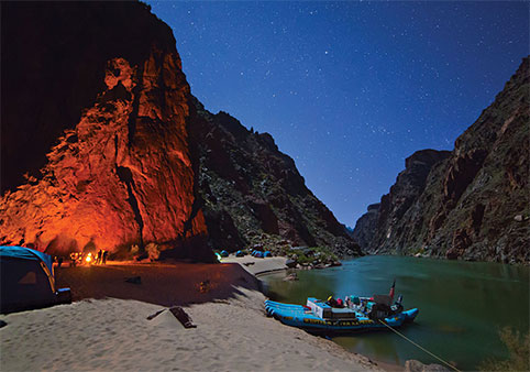
The Colorado River is central to the canyon's development, but it is not visible from every overlook. Inner-canyon ridges, bends, plateaus, and rock formations frequently block the line of sight from the rim.
When the river is visible, it may appear as a narrow green, brown, silver, or dark ribbon. Its apparent size is deceptive. The immense vertical and horizontal distance compresses the river and surrounding landscape when viewed from above.
Following separate visible sections can help reconstruct the river's course. A stretch that disappears behind a ridge may reappear miles away after bending around formations hidden from view.
The river does not work alone. Debris flows from side canyons, sediment transport, groundwater, weathering, rockfall, and erosion throughout the drainage network all contribute to the evolving canyon.
Read the Canyon's Rock Record
Three Broad Sets of Rocks
Grand Canyon rocks can be organized into three broad groups. Each occupies a different part of the landscape and records a different chapter of Earth history.
Layered Paleozoic Rocks
The upper canyon walls contain mostly flat-lying sedimentary formations. These layers form the prominent cliffs and slopes seen from many overlooks.
They preserve evidence of ancient seas, coastal environments, tidal flats, river systems, deserts, and other landscapes that existed hundreds of millions of years ago.
Grand Canyon Supergroup
In parts of the eastern canyon, older sedimentary and volcanic rocks appear below the flat-lying upper layers. These formations are commonly tilted and are collectively known as the Grand Canyon Supergroup.
Their tilted appearance makes them especially useful for recognizing that the canyon's rock record includes episodes of deposition, deformation, faulting, uplift, erosion, and missing time.
Vishnu Basement Rocks
The oldest exposed rocks occur near the bottom of the canyon. These crystalline rocks formed deep within ancient mountain systems and were later exposed by uplift and erosion.
The contact between these ancient rocks and younger formations above them represents an enormous span of geologic history.
Rock Color Is Only Part of the Story
Color can help distinguish formations, but it should not be used alone. The same rock may appear cream, gray, orange, red, brown, purple, or nearly black depending on distance, moisture, surface coatings, shadow, and the angle of sunlight.
Iron-bearing minerals contribute many red and orange tones, but surface staining can color a rock differently from its freshly broken interior. Vegetation, lichens, desert varnish, and weathered debris can also change the appearance of a formation.
Shape and position are often more reliable clues than color. Notice whether a formation makes a cliff or slope, which layer sits above or below it, and whether it can be followed across nearby walls.
Missing Time in the Canyon Walls
The canyon walls do not preserve an uninterrupted record of Earth history. Some intervals are absent because sediments were never deposited, previously formed rocks were eroded, or later events removed part of the record.
The boundaries representing these gaps are called unconformities. Some encompass hundreds of millions of years.
An unconformity may appear visually modest, sometimes no more than a contact between two formations, while representing more time than all of recorded human history multiplied many times over.
Flat Layers and Tilted Layers
Many of the upper sedimentary formations appear nearly horizontal. This reflects both how the sediments were deposited and the broad uplift history of much of the Colorado Plateau.
Other rocks are tilted, folded, fractured, or displaced along faults. The tilted Grand Canyon Supergroup in the eastern canyon provides one of the clearest contrasts with the flatter Paleozoic layers above it.
Faults may guide drainage, influence springs, weaken rock, or place formations at different elevations on opposite sides of a fracture. Not every straight canyon or visible line is a fault, however. Confirming a fault requires geological evidence rather than shape alone.
The Rocks Are Older Than the Canyon
One of the most important distinctions in Grand Canyon geology is the difference between the age of the rocks and the age of the landscape carved into them.
Some exposed rocks are nearly two billion years old. The youngest major formation forming the rims is about 270 million years old. The recognizable canyon and integrated Colorado River system are far younger.
Scientific research continues to refine how the river became connected across the region and how older canyon segments, drainage systems, uplift, erosion, and river incision contributed to the present landscape. The canyon should not be imagined as having appeared all at once when one river began cutting into a flat surface.
Notice What Changes from One View to Another
Elevation and Vegetation
The Grand Canyon crosses a major elevation range. Forests grow on the rims, woodlands occupy many intermediate elevations, and increasingly desert-adapted plant communities appear deeper in the canyon.
North-facing slopes generally receive less direct sunlight and may retain cooler, moister conditions than nearby south-facing slopes. Differences in exposure can create visible contrasts in vegetation even at similar elevations.
Springs, seeps, and tributaries create narrow concentrations of plant life. A green strip in a dry side canyon may indicate the presence of water that cannot otherwise be seen from the rim.
Light, Shadow and Apparent Color
The canyon changes as sunlight moves across it. Morning and evening light strike formations at lower angles, emphasizing cliffs, ridges, and differences in relief. Near midday, overhead light can reduce visible texture while illuminating areas that remain deeply shadowed at other times.
The most dramatic color is not always in the direction of the sun. At sunrise or sunset, formations across the canyon may receive warm direct light while the horizon behind the sun appears comparatively subdued.
Clouds can create isolated pools of light and rapidly moving shadows. Snow, rain, wet rock, smoke, and airborne dust can transform both color and visibility.
Atmospheric Perspective
Distant formations often appear lighter, bluer, flatter, and less distinct than nearby ones. This effect is called atmospheric perspective.
Light traveling from distant objects passes through more air. Moisture, dust, smoke, and other particles scatter light and reduce contrast. As a result, a faraway plateau may seem faded even when its rocks are similar in color to those nearby.
Atmospheric perspective helps communicate distance to the human eye, but it also makes the canyon difficult to judge accurately. Features that appear close together may be separated by miles of cliffs and side canyons.
Scale and Distance
The canyon's scale can overwhelm familiar visual clues. Trees may appear as tiny dots, large buildings may be difficult to identify, and the Colorado River can look narrow enough to step across.
Overlapping formations also compress depth. A butte in the foreground may appear to touch a distant wall even though a deep side canyon lies between them.
One useful method is to look for known objects. Trails, buildings, people, trees, roads, and river rafts can provide scale, although some may be too small to see without binoculars.
Walking along the rim provides another clue. As the viewing angle changes, formations that appeared joined begin to separate, revealing the hidden depth between them.
Weather and Visibility
A clear view is not necessarily the only valuable view. Rain and snow reveal drainage patterns. Low clouds emphasize the rims and isolate formations. Storm light can show relief that disappears under an evenly blue sky.
Weather can also conceal hazards. Clouds may hide approaching thunderstorms, smoke can reduce air quality, and snow or ice can make rim surfaces dangerous even when distant scenery remains visible.
Lightning is a serious risk along exposed rims. A viewpoint should be left when thunderstorms approach rather than treated as a place to watch the storm arrive.
A Cultural Landscape
A Grand Canyon view is not only geological scenery. The canyon is an ancestral homeland and a living cultural landscape connected with Indigenous nations whose relationships with these places continue today.
Peaks, springs, trails, river crossings, side canyons, gathering places, archaeological sites, and distant landmarks may hold cultural meanings that are not apparent from an overlook.
Historic roads, mines, buildings, trails, and tourist facilities also shape what visitors see. Even the location and design of a viewpoint reflect decisions about access, interpretation, architecture, land management, and which stories were presented to the public.
Reading the canyon responsibly means recognizing that a landscape can be scientifically studied, culturally significant, historically contested, and personally meaningful at the same time.
Educational Viewpoints
Every overlook can reveal part of the canyon, but several are particularly useful for studying specific landscape relationships.
Yavapai Point
Yavapai Point provides a broad central-canyon view beside Yavapai Geology Museum. It is a useful place to compare the upper sedimentary sequence, isolated formations, side canyons, and the inner gorge.
The nearby Trail of Time extends westward along the rim and uses distance to represent geologic time. Walking the trail helps connect rocks in the landscape with the enormous intervals they represent.
Read the Landscape from Yavapai Point »
Lipan Point
Lipan Point provides an unusually long view of the Colorado River corridor. It is also useful for observing the tilted rocks of the Grand Canyon Supergroup and their relationship with the flatter layers above.
Read the Landscape from Lipan Point »
Grandview Point
Grandview Point reveals a complex network of ridges, side canyons, cliffs, and plateaus. It also connects geological interpretation with mining, trail, and early tourism history.
Point Imperial
Point Imperial looks toward the eastern canyon and the transition into Marble Canyon. Its elevation and orientation help illustrate how the character of the canyon changes along the river corridor.
Read the Landscape from Point Imperial »
Cape Royal
Cape Royal provides a broad North Rim perspective across the eastern Grand Canyon. The view includes isolated formations, complex tributary canyons, distant plateaus, and portions of the Colorado River corridor.
A Simple Way to Read Any View
When arriving at an overlook, begin with the largest features and work toward the details.
- Find the rim. Identify the plateau surface and compare the elevation of the opposite rim.
- Follow the layers. Notice which formations create cliffs and which create slopes.
- Look for isolated remnants. Match layers on buttes or temples with the main canyon walls.
- Trace the side canyons. See how tributary drainages branch toward the central corridor.
- Locate the inner gorge. Look for the dark, steep-walled canyon cut into ancient crystalline rocks.
- Search for the river. Follow visible sections and imagine how hidden bends connect them.
- Notice vegetation. Compare forests, woodlands, desert slopes, and green corridors associated with water.
- Account for the atmosphere. Consider how distance, haze, clouds, light, and shadow are changing the scene.
- Remember the human landscape. Ask whose homeland, history, knowledge, and decisions are connected with the place before you.
A Grand Canyon view does not become smaller when its parts are understood. It becomes deeper. Cliffs turn into ancient environments, empty-looking spaces become vanished rock, green lines reveal water, and distant formations begin to show their relationship with the river below.
Observe from a Safe Location
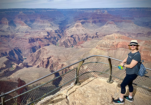
Understanding the landscape does not require approaching an exposed edge. Many overlooks contain loose gravel, fractured rock, uneven surfaces, snow, ice, or strong wind.
Remain behind barriers where provided, stay on established surfaces, supervise children closely, and move away from exposed rim areas when thunderstorms approach.
Continue Learning
Explore the rocks, water, ecosystems, and human histories that shape what can be seen from the rim.