The Grand Canyon is one of the most spectacular landscapes on Earth, yet it did not appear overnight or form from a single geological event. Instead, the canyon is the result of hundreds of millions of years of changing environments, the slow uplift of an entire region, and the relentless work of rivers, weather, and gravity. Every cliff, side canyon, and rock layer records part of a story that continues today.
One of the most common misconceptions is that the Colorado River alone created the Grand Canyon. While the river played a central role, it could not have carved the canyon without several other geological processes working together. Ancient rock layers had to be deposited first, the Colorado Plateau had to rise thousands of feet, and erosion from rain, snow, wind, and tributary streams had to widen the canyon long after the river began cutting downward.
Scientists continue to study exactly how and when different parts of the canyon formed, but the overall sequence is well understood. The Grand Canyon is best viewed as the product of many interconnected geological events rather than a single moment in Earth's history.
Before There Was a Canyon
Long before the Colorado River carved through northern Arizona, the region looked nothing like it does today. Over hundreds of millions of years, seas advanced and retreated, deserts expanded, rivers crossed broad plains, and sediments slowly accumulated into the rock layers visible throughout the canyon today.
Building the Rock Layers
Between roughly 525 and 270 million years ago, northern Arizona experienced repeated changes in climate and sea level. During some periods the area lay beneath warm, shallow oceans filled with marine life. At other times it became a sandy desert, a coastal plain, or a network of rivers and floodplains.
Each environment deposited its own layer of sediment. Sand became sandstone, mud became shale, and shell fragments accumulated into limestone. Together these deposits created the sequence of sedimentary rocks that now forms the canyon walls.
Even older rocks beneath these layers record volcanic activity, mountain building, and continental collisions dating back nearly two billion years. Although they make up only the deepest part of the canyon, they provide the foundation for everything that came later.
A Nearly Flat Landscape
Once the major sedimentary layers had formed, the region remained relatively stable for tens of millions of years. Instead of dramatic mountain ranges, much of what is now northern Arizona consisted of a broad landscape with only modest changes in elevation.
During this time, erosion removed some younger rock layers that had once covered the area. These missing chapters in Earth's history created geological gaps known as unconformities, where millions of years of the rock record simply disappeared before newer events reshaped the landscape.
Although little evidence remains of these ancient surfaces, they remind geologists that landscapes are constantly changing. Sometimes rocks are being deposited, while at other times they are being worn away.
The Rise of the Colorado Plateau
Beginning roughly 70 million years ago during the Laramide Orogeny, forces deep within Earth's crust slowly lifted a vast region now known as the Colorado Plateau. Unlike many mountain-building events, this uplift occurred with relatively little folding or deformation of the rock layers.
Instead of being crumpled into steep mountain ranges, the sedimentary rocks remained remarkably level while the entire plateau gradually rose thousands of feet above sea level. Today much of the Colorado Plateau stands between 5,000 and 9,000 feet in elevation.
This uplift dramatically changed the landscape. Rivers flowing across the plateau suddenly had much steeper gradients, giving them greater energy to erode downward into the rising land.
Without the uplift of the Colorado Plateau, the Colorado River would likely have meandered across a relatively flat landscape instead of carving one of the deepest canyons in the world.
Carving the Grand Canyon
With ancient rock layers already in place and the Colorado Plateau rising thousands of feet, the stage was finally set for canyon formation. Over millions of years, flowing water, gravity, and weathering worked together to carve the landscape visitors see today.
The Colorado River Finds Its Path
The modern Colorado River did not simply appear and begin carving the canyon overnight. Scientists believe today's river developed as several older drainage systems gradually became connected. As the plateau continued to rise, streams flowing toward the Gulf of California eventually linked together, creating a continuous river capable of cutting through the uplifted landscape.
Most geologists agree that much of the canyon visible today was carved within the last five to six million years. Once an integrated Colorado River formed, it had both the elevation drop and the water flow needed to erode downward into the plateau.
The river acted like a conveyor belt, carrying away sand, gravel, and rock that had been broken loose from the canyon walls. As long as material continued to be removed, the river was able to deepen its channel over time.
More Than Just a River
Although the Colorado River carved the deepest part of the canyon, it did not work alone. Every rainstorm, snowmelt, rockfall, and freeze-thaw cycle helped widen the canyon from the sides while the river continued cutting downward.
Water seeped into cracks within the rock, expanded as it froze during colder periods, and gradually broke larger blocks free. Gravity carried these rocks onto the slopes below, where floods and tributary streams transported smaller fragments toward the river.
This combination of weathering, erosion, and mass movement continues to reshape the canyon today, even in places far above the Colorado River itself.
Weathering and Erosion Work Together
Once the Colorado River established its course, it continued cutting downward into the uplifted Colorado Plateau. At the same time, countless other natural processes widened the canyon from above. Geologists distinguish between erosion, which transports rock and sediment, and weathering, which breaks rock apart in place. Both are essential to understanding how the Grand Canyon formed.
Water is the most important agent of change. Rainstorms wash loose sediment into side canyons, while seasonal snowmelt feeds streams that carry rock fragments toward the Colorado River. During winter, water that seeps into cracks freezes and expands, gradually prying apart even solid cliffs. This process, known as freeze-thaw weathering, is responsible for many of the rockfalls that occur throughout the canyon.
Wind also contributes by removing fine sediment and exposing fresh rock surfaces, although its role is much smaller than that of flowing water. Gravity constantly pulls loosened rocks downslope, creating talus piles at the base of cliffs that are eventually carried away during floods.
Rather than one dramatic event, the Grand Canyon is shaped by millions of small changes occurring every year.
Why Different Rocks Erode Differently
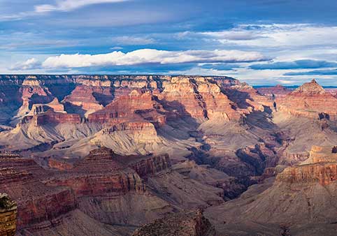
One reason the Grand Canyon has such dramatic scenery is that its rock layers do not erode at the same rate. Hard, resistant rocks such as limestone and sandstone tend to form towering cliffs, while softer rocks like shale and mudstone weather more quickly into broad slopes.
This process, called differential erosion, creates the canyon's distinctive stair-step profile. The bright cliffs of the Coconino Sandstone, the massive walls of the Redwall Limestone, and the gentle slopes of the Bright Angel Shale all exist because each rock type responds differently to weathering.
Understanding differential erosion allows visitors to recognize many of the canyon's major formations even without geological training.
Side Canyons Tell the Same Story
The Colorado River carved the canyon's deepest channel, but hundreds of tributary streams helped create its immense width. During heavy rains, normally dry washes become powerful torrents capable of moving boulders, trees, and enormous amounts of sediment.
Over millions of years, these tributaries carved countless side canyons that branch away from the main canyon like veins on a leaf. Famous examples include Bright Angel Canyon, Havasu Canyon, and Tapeats Creek, each adding complexity to the landscape.
These tributaries continue delivering sediment to the Colorado River today, allowing the canyon to evolve long after its initial formation.
The Canyon Never Stops Changing
Although the Grand Canyon appears timeless, it remains an active geological landscape. Flash floods reshape drainage channels, rockfalls alter cliffs, debris flows fill gullies, and the Colorado River continues transporting sediment downstream.
Modern dams have reduced the river's natural sediment load and changed the timing of seasonal floods, but natural erosion continues throughout the canyon. Every year, countless small geological events subtly reshape the landscape, even if the overall changes are too slow for most visitors to notice.
What Scientists Are Still Studying
The broad story of the Grand Canyon's formation is well established, but geologists continue investigating exactly when different portions of the canyon formed and how ancient river systems evolved before the modern Colorado River became established.
One Canyon, Several Theories
For many years, scientists believed nearly the entire canyon formed within the past five to six million years after the Colorado River became fully integrated. More recent research has suggested that some portions of the canyon may have originated much earlier as isolated ancient valleys that were later connected by the modern river.
These studies use techniques such as radiometric dating, thermochronology, and analysis of river sediments to reconstruct events that occurred millions of years ago. As new evidence becomes available, scientists continue refining their understanding of the canyon's complex history.
What Most Geologists Agree On
Despite ongoing research, there is broad scientific agreement on several key points. The sedimentary rock layers were deposited long before the canyon formed. The Colorado Plateau was uplifted during the Laramide Orogeny. The Colorado River became integrated several million years ago and began rapidly cutting into the plateau. Weathering, tributary streams, and gravity widened the canyon while the river deepened it.
Although researchers may debate specific dates and local details, these fundamental processes explain how the Grand Canyon developed into the landscape visitors see today.
The Story Is Still Being Written
The Grand Canyon is often described as a geological snapshot, but it is more accurate to think of it as an ongoing process. Rivers continue to erode bedrock, cliffs occasionally collapse, side canyons lengthen, and weather slowly reshapes every exposed rock surface.
Millions of years from now, the canyon will almost certainly look different than it does today. Some cliffs will retreat, new rockfalls will occur, and tributaries will continue expanding the landscape. The forces that created the Grand Canyon have never truly stopped. They simply work on a timescale much longer than a human lifetime.
Frequently Asked Questions
Did the Colorado River create the Grand Canyon by itself?
No. While the Colorado River carved the deepest part of the canyon, it worked alongside many other geological processes. The Colorado Plateau first had to be uplifted thousands of feet, and weathering, tributary streams, gravity, and erosion all helped widen the canyon into the landscape visible today.
How long did it take the Grand Canyon to form?
The rock layers exposed in the canyon were deposited over hundreds of millions of years, but much of the modern canyon was carved during the last five to six million years after the Colorado River became fully established. The landscape continues to evolve today.
How old is the Grand Canyon?
The answer depends on whether you're referring to the rocks or the canyon itself. The oldest exposed rocks are nearly two billion years old, while most geologists agree that the modern canyon largely developed within the last five to six million years.
Is the Grand Canyon still getting deeper?
Yes. The Colorado River continues to erode its channel, although at a much slower pace than in the past. Weathering, rockfalls, flash floods, and tributary streams also continue reshaping the canyon every year.
Did glaciers carve the Grand Canyon?
No. Unlike places such as Yosemite Valley, the Grand Canyon was not carved by glaciers. It formed primarily through river erosion, weathering, gravity, and the uplift of the Colorado Plateau.
Why didn't the rock layers collapse as the canyon formed?
The canyon was carved gradually over millions of years rather than all at once. Strong rock formations continue supporting steep cliffs, while weaker layers erode into broad slopes. Occasional rockfalls occur naturally and remain part of the canyon's ongoing evolution.
What role did the Colorado Plateau play?
The uplift of the Colorado Plateau gave the Colorado River the elevation drop needed to cut downward into the landscape. Without this uplift, the river would have lacked the energy necessary to carve such a deep canyon.
Why do scientists still debate parts of the canyon's history?
Geologists continue studying exactly when different sections of the canyon formed and how ancient river systems became connected. While details continue to be refined through new research, the overall sequence of deposition, uplift, river incision, and erosion is well supported.
Will the Grand Canyon ever stop changing?
No. As long as rivers flow, storms occur, temperatures fluctuate, and gravity pulls rocks downhill, the canyon will continue evolving. These changes happen slowly, but the landscape is never truly static.
Continue Learning
The Grand Canyon formed through a combination of geological events spanning hundreds of millions of years. Continue exploring the science behind one of Earth's greatest natural wonders.