Cedar Ridge is where the South Kaibab Trail begins to feel less like a path descending from the rim and more like a journey into the Grand Canyon itself. Located approximately 1.5 miles below the trailhead, the broad ridge gives hikers room to stop, look in several directions, and appreciate how quickly the landscape has changed.
At Ooh Aah Point, the canyon first reveals itself from below the rim. At Cedar Ridge, that revelation expands. The South Rim rises behind you, distant formations separate into distinct landmarks, and the trail ahead drops toward an increasingly complex world of ridges, side canyons, and ancient rock.
For many visitors, Cedar Ridge is the most rewarding turnaround point for a substantial half-day hike. It delivers a genuine below-the-rim experience without requiring the much greater commitment of continuing to Skeleton Point or the Colorado River.
Cedar Ridge at a Glance
| Feature | Details |
|---|---|
| Trail | South Kaibab Trail |
| Distance | Approximately 3 miles round trip |
| Elevation | Approximately 6,120 feet |
| Elevation Change | About 1,140 feet below the trailhead |
| Typical Hiking Time | 2 to 4 hours |
| Difficulty | Moderate to strenuous because of the exposed uphill return |
| Water | No water available at Cedar Ridge |
| Restrooms | Primitive toilets are typically available |
| Best For | A substantial half-day hike and an immersive canyon experience |
The National Park Service identifies Cedar Ridge as a 1.5-mile destination from the South Kaibab Trailhead and describes it as an ideal day hike with excellent views. The trail is exposed, with little shade and no water along the route. :contentReference[oaicite:0]{index=0}
What Changes Between Ooh Aah Point and Cedar Ridge?
The short distance between Ooh Aah Point and Cedar Ridge creates a surprisingly large change in perspective. Ooh Aah Point still feels connected to the upper trail and the nearby rim. Cedar Ridge feels farther removed from the developed South Rim and more deeply embedded in the canyon landscape.
| At Ooh Aah Point | At Cedar Ridge |
|---|---|
| The South Rim remains close overhead. | The rim begins to feel distinctly distant. |
| The canyon first opens into view. | The landscape surrounds you in several directions. |
| Most visitors stop briefly at the overlook. | The broad ridge invites a longer rest and closer observation. |
| The hike still feels short and connected to the trailhead. | The return climb becomes a significant physical commitment. |
| The canyon appears as one dramatic panorama. | Individual ridges, temples, and side canyons become easier to distinguish. |
Why Cedar Ridge Feels Like a Destination
Cedar Ridge is wider and more open than many points along the upper South Kaibab Trail. Instead of occupying a narrow bend or small overlook, hikers arrive on a broad saddle with space to rest and study the canyon from several angles.
This openness creates a psychological milestone. The trailhead is no longer just around the corner, and the route ahead is clearly visible as it continues toward Skeleton Point. Cedar Ridge feels like a destination because it marks the transition from a short scenic descent to a more serious inner-canyon journey.
The Turning Point
Cedar Ridge is often where hikers begin thinking less about how far they have descended and more about how much climbing remains. The view invites you onward, but the return to the rim is already a substantial ascent.
The View from Cedar Ridge
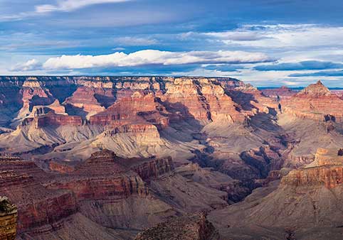
Cedar Ridge offers expansive views across the central Grand Canyon and back toward the South Rim. The exposed ridgeline makes it easier to see how side canyons divide the landscape and how isolated formations rise between major drainages.
Looking upward reveals the height already lost since leaving the trailhead. Looking downward reveals how much farther the South Kaibab Trail continues toward Skeleton Point, the Inner Gorge, and eventually the Colorado River.
| What to Look For | What It Reveals |
|---|---|
| The South Rim above | How quickly the trail descends through the upper rock layers |
| Hikers on the ridgeline | The immense scale of the surrounding formations |
| Side canyons | How tributary erosion widens the Grand Canyon |
| The trail toward Skeleton Point | The increasing exposure and commitment of continuing downward |
| Changing vegetation | The transition toward a warmer and drier inner-canyon environment |
Why the Ridge Is So Exposed
The South Kaibab Trail follows an open ridgeline rather than descending within a shaded side canyon. That alignment creates extraordinary views, but it also exposes hikers to direct sun, wind, passing storms, and rapidly changing temperatures.
Shade is limited, especially after the upper portion of the trail. During warm weather, the same open terrain that makes Cedar Ridge so photogenic can make the return climb much harder than expected. The National Park Service warns that the trail's openness contributes to extreme summer heat and offers little protection from storms. :contentReference[oaicite:1]{index=1}
What the Geology Reveals
The descent to Cedar Ridge carries hikers through several of the Grand Canyon's younger upper rock formations. From the ridge, those layers are no longer merely stripes across a distant wall. They become cliffs, slopes, ledges, and trail surfaces underfoot.
This is one of the most important interpretive changes below the rim. Geology stops being an abstract diagram and becomes physical terrain. Harder layers form prominent cliffs, while softer formations erode into gentler slopes that the trail can cross.
| Geological Clue | What It Means |
|---|---|
| Sheer cliffs | More resistant rock layers erode slowly |
| Broad slopes | Softer formations weather and retreat more easily |
| Loose rock beneath the trail | Freeze-thaw cycles and erosion continue breaking the canyon apart |
| Separated ridges | Side drainages have carved through the plateau over time |
Getting to Cedar Ridge
Cedar Ridge is reached from the South Kaibab Trailhead near Yaki Point. Private vehicles are not permitted on the access road, so most hikers use the Kaibab Rim Orange Route shuttle from the Grand Canyon Visitor Center or the seasonal Hikers' Express.
The Orange Route trip from the Visitor Center to the South Kaibab Trailhead takes about nine minutes. Shuttle hours and frequency change seasonally, so verify the current schedule before planning an early start or late return. :contentReference[oaicite:2]{index=2}
No Water Means No Margin for Guessing
Carry All the Water You Need
There is no drinking water at Cedar Ridge or elsewhere along the South Kaibab Trail. Water may be available at the trailhead, but hikers should verify current conditions and begin with enough for the complete round trip.
Remember the Return
The hike back is entirely uphill, exposed, and often warmer than the descent. Reaching Cedar Ridge uses only part of the energy and water required for the full hike.
Frequently Asked Questions
How far is Cedar Ridge?
Cedar Ridge is approximately 1.5 miles (2.4 km) one way from the South Kaibab Trailhead, making it about a 3-mile round-trip hike.
Is Cedar Ridge worth hiking?
Yes. Many experienced Grand Canyon hikers consider Cedar Ridge one of the best turnaround points for a half-day hike because it provides an immersive below-the-rim experience without requiring the much longer commitment of reaching the Colorado River.
Can beginners hike to Cedar Ridge?
Many first-time hikers successfully reach Cedar Ridge, but they should remember that every step downhill must be climbed back to the rim. The return hike is significantly more demanding than the descent.
Is there water at Cedar Ridge?
No. There is no drinking water along the South Kaibab Trail below the trailhead. Every hiker should begin with sufficient water for the entire round trip.
Can you see the Colorado River from Cedar Ridge?
Generally, no. While the canyon views are extensive, the Colorado River remains hidden from Cedar Ridge. Continuing to Skeleton Point provides one of the first opportunities to see the river from the South Kaibab Trail.
Are there restrooms at Cedar Ridge?
Yes. Primitive composting toilets are typically available near Cedar Ridge, although visitors should never rely on them as their only option and should check current park information before hiking.
What is the best time of year to hike Cedar Ridge?
Spring and fall usually provide the most comfortable hiking conditions. Summer temperatures below the rim can become dangerously hot, while winter may bring snow or icy trail conditions near the South Rim.
Should I continue beyond Cedar Ridge?
Only if you have the time, supplies, and energy for a significantly longer hike. Beyond Cedar Ridge, the trail continues toward Skeleton Point, where hikers gain their first views of the Colorado River and descend much farther into the canyon.
The GrandCanyon.net Trail Experience Scorecard
| Experience | Rating |
|---|---|
| Scenic Views | ★★★★★ |
| Interpretive Value | ★★★★★ |
| Photography | ★★★★★ |
| Geology | ★★★★☆ |
| First-Time Hikers | ★★★★☆ |
| Overall Experience | ★★★★★ |
What Changes Here?
Your Confidence
By the time you reach Cedar Ridge, you've moved beyond the "first look" of Ooh Aah Point. The canyon begins to feel less intimidating and more understandable.
Your Awareness of Distance
The South Rim is no longer just behind you. Looking back reveals how quickly the trail has descended, while looking ahead emphasizes how much farther the canyon continues toward the river.
Your Understanding of Geology
Rock layers that appeared as distant bands from the rim now surround you. You begin walking across the formations instead of simply looking at them.
Your Decision
Cedar Ridge is often where hikers decide whether to continue deeper into the canyon or begin the climb back to the South Rim. It marks the transition from a scenic walk to a more committed inner-canyon hike.
Our Recommended Cedar Ridge Experience
Start Before Mid-Morning
An early departure provides cooler temperatures, quieter trails, and softer light for photography.
Take Breaks Along the Ridge
Cedar Ridge is meant to be experienced, not simply reached. Walk slowly around the open ridge and observe how the landscape changes in every direction.
Study the Canyon Walls
Look carefully at the cliffs above and below you. Notice how resistant rock layers form vertical walls while softer layers create broader slopes.
Continue Only If Prepared
Skeleton Point offers the next major interpretive milestone, but the hike becomes considerably longer and more demanding beyond Cedar Ridge.
Continue Exploring the South Kaibab Trail
Every destination along the South Kaibab Trail reveals another chapter in the Grand Canyon story. Continue exploring to see how the landscape changes with each step below the rim.